Joaquin upgraded to Cat 3 hurricane as East Coast braces for more flooding (VIDEO)
The East Coast is bracing for a weekend of potential flooding as Hurricane Joaquin bears down on the Bahamas. The storm was upgraded from a tropical storm to a Category 3 hurricane, and weather forecasters expect it to turn northwards towards the US.
Joaquin’s winds “have increased to near 75 mph (120 km/h) with higher gusts,” according to Air Force Reserve Hurricane Hunter reconnaissance aircraft measurements.
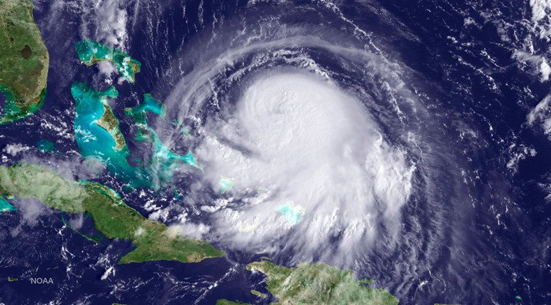
Hurricane Joaquin is intensifying slowly, as the wind shear drops. The storm’s 55-mile-wide eye remains open on the north side.
#Joaquin becomes a hurricane over night. Find the most recent warnings and forecast here http://t.co/PivIdwqWtkpic.twitter.com/pKtVkZsJcv
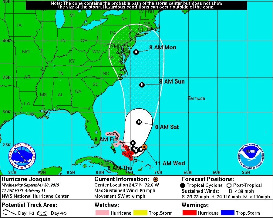
— NOAA Satellites (@NOAASatellites) September 30, 2015Originally listed as a Category 1 cyclone, it was upgraded to Category 3 Wednesday evening by the US National Hurricane Center. Hurricane warnings and watches are in effect for much of the Bahamas. The storm is expected to arrive near the central part of the coral-based archipelago Wednesday night and Thursday.
#NOAA49 (@NOAA GIV) captured this image from #JOAQUIN this evening. The night crew heads out soon. pic.twitter.com/HyQClbBjMG
— NOAAHurricaneHunters (@NOAA_HurrHunter) September 30, 2015Hurricane force winds ‒ meaning wind speeds of 74 to 95 mph (119-153 km/hr) ‒ extend outward up to 30 miles (50 km) from the center. Tropical storm force winds ‒ meaning wind speeds between 39 mph and 73 mph (63-118 km/hr) ‒ extend outward up to 125 miles (205 km) from the center.
Air Force recon collecting data on #Joaquin as we speak. GPS drops show avg. wind in lowest 500m ~85 mph, E of center pic.twitter.com/vs45gImiLG
— Greg Postel (@GregPostel) September 30, 2015The storm will move southwest through Wednesday night before turning north towards the US. One model, the American GFS, predicted an “alarming northwestward turn,” the Weather Channel said, with the storm slamming into Virginia and Maryland over the weekend.
However, another, the European ECMWF model, shows Joaquin running parallel to the East Coast and offshore before turning to the northeast and heading further out to the North Atlantic off New England and Canada’s eastern provinces.
As Category 3 cyclone, it is classified as a “major hurricane” with sustained wind speeds between 111 and 129 mph (178-208 km/hr).
“Joaquin's future depends critically on the position and relative strength of those players – not to mention its own strength,” the Weather Channel said. “It's a particularly difficult forecast that hinges on the behavior of several different atmospheric features over North America and the North Atlantic Ocean.”
The most recent visible imagery of Hurricane #Joaquin from the GOES-13 satellite (GOES-East) http://t.co/f9Jma9ofmfpic.twitter.com/G9qSYsVTDB
— NOAA Satellites (@NOAASatellites) September 30, 2015Forecasters are struggling to predict Joaquin’s path and intensity because of the uncertainty with how the hurricane will interact with a complex set of other weather factors, including a cold front near the East Coast, the remnants of Tropical Storm Ida, a strong bubble of high pressure aloft over the North Atlantic Ocean and a potentially strong area of low pressure over the US Southeast towards the end of the week.
Latest (06z) GFS has big NC/VA #Joaquin landfall. 3rd run in a row w/ similar solution and many other models agree. pic.twitter.com/nQKqqo6Mx8
— Eric Holthaus (@EricHolthaus) September 30, 2015The East Coast, which was slammed by torrential downpours that caused flash flooding Tuesday night and into Wednesday morning, can expect more flooding this weekend, regardless of whether Joaquin makes landfall.
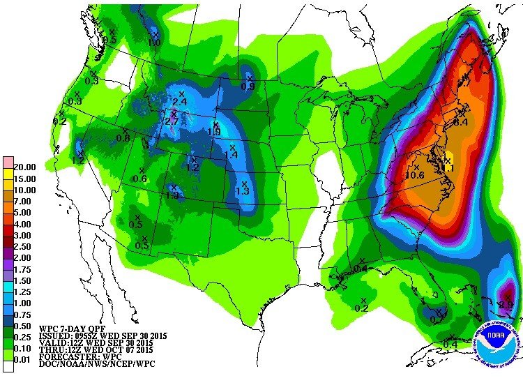
The areas hit by that storm spread from Virginia in the south ‒ where the Roanoke River crested at 9.32 feet at Shawsville on Tuesday, above the 9-foot "major flood" threshold ‒ to Maine in the north ‒ where much of Portland is covered in 5 inches of rain ‒ and as far west as Ohio ‒ where Wheeling Creek was reportedly flooded out of its banks and onto US Route 40 in Blaine.
Early afternoon visible shot of #Joaquin reveals an eye feature with stronger storms on the western side. pic.twitter.com/oXxVClVpCf
— HurricaneTracker App (@hurrtrackerapp) September 30, 2015