‘Tinderbox’: 20% of California’s forests might die – research
A lead scientist for the Carnegie Airborne Observatory spent three weeks flying over California’s forests in Sacramento and Bakersfield in order to laser map them. The results were shocking: up to 20 percent of the state’s forests are at risk of dying. The results come as California endures its fourth year of drought and its worst forest fire season in history.
The Carnegie team used a special plane outfitted with two special instruments with which they could map millions of trees a day – a LiDAR and an image spectrometer. The LiDAR fires two lasers out of the bottom of the plane that capture 3D images of the forest, and the image spectrometer measures the chemical makeup of trees. The instruments allowed Carnegie’s Greg Asner to rapidly measure trees in bulk – about 8 million per hour – rather than having to measure individual trees by hand.
Drought-stressed California forests face a radical shift https://t.co/I2yGaJFhSEpic.twitter.com/oPgYA9zEac
— Ecology Pictures (@EI_EcoPictures) October 20, 2015A unique set of sensors were employed to reveal the trees’ water content, an indicator of whether they are stressed by drought or likely to die.
“We’ve been all over the state…And we’ve seen everything from forests that are doing just fine to other forests that are in real trouble where we’re seeing lots of mortality, extreme drought stress, scary stuff in different parts of the state,” Asner told Al Jazeera America.
Asner was able to assess the health of each individual tree and generate three-dimensional snapshots. He discovered that 120 million trees are dying across the state. Healthy trees are depicted as blue, and drought stressed trees run from mild yellow to severe red.
FASCINATING: X-ray tech reveals CA's forests are in for a radical transformation #cadroughthttps://t.co/Kj8CZwrhZipic.twitter.com/1iGNTgaRM4
— Matt Stevens (@ByMattStevens) October 20, 2015A spectrometer shows how much water is in the trees’ leaves – less reflected light shows that the leaves contain more water, while more reflected light indicates they are dry. When compiled, the data provides a topographic image illustrating the condition of a forest.
“At what point will the forest change into something else? We don’t know,” Asner told the Los Angeles Times. “We don’t know when the lack of rain will lead to runaway conditions where the forests are beyond repair.”
Asner estimates there are 585 million to 1.6 billion trees in the state’s forests. An accurate census, he told the Times, has never been conducted, but 120 million trees represents anywhere from 7 percent to 20 percent of the state’s forests.
Widespread forest mortality due to #CAdrought. @carnegiescience via @tcurwen#CAfirehttps://t.co/udmsSMNKeVpic.twitter.com/kDsZvon9Ix
— Daniel Swain (@Weather_West) October 20, 2015By comparison, Asner said healthy forests lose between 1 percent and 1.5 percent of their trees annually under normal circumstances.
“I’ve seen shocking views of severe drought stress. I’ve seen places that on the map or on Google earth look green, but when you fly over them, they don’t look like forests anymore,” Asner told Al Jazeera. “We’re starting to see this in the southern forests in particular. We haven’t seen that in the northern forests yet, but if the drought continues we expect to see this massive shocking wave of mortality and tree loss occur up here.”
The Forest Service had estimated that nearly 12.5 million trees in the state’s southern and central forests were dead, but Asner’s estimates are far worse. He says the mountains ringing Los Angeles are a “tinderbox,” and the oak forests in the Sierra foothills are “in big trouble.”
While the threat of a massive tree die-off is serious, aerial images can help land managers identify vulnerable terrain and consider how to strengthen stressed trees and protect healthy ones.
#wildfires scorches California [VIDEO] https://t.co/VKLuJbrH40@Brigida__Santos
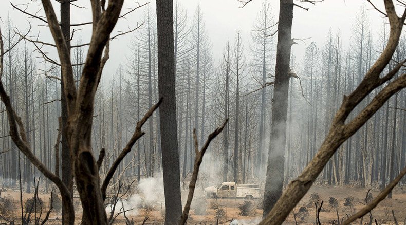
— RT America (@RT_America) September 15, 2015California is already under a state of emergency because of its drought and has had firefighters respond to nearly 6,800 fires in this year alone. The devastating Valley Fire destroyed more than 585 homes and over 73,000 acres, according to the state Department of Forestry and Fire Protection.
“Diminishment of the state’s forests means the loss of clean water and erosion control, recreation and jobs,” Ashley Conrad-Saydah of the California Environmental Protection Agency told the LA Times on seeing Asner’s topographic images. “As trees die, decompose or burn, carbon is released into the atmosphere, contributing to global warming. Forests become scrublands with 97 percent less carbon.”
BREAKING: 'Life threatening' flooding, mudslides reported in Southern California http://t.co/0NcH0eB6HSpic.twitter.com/QKOZFY0qVi
— RT America (@RT_America) October 16, 2015