NASA satellite image captures devastation of Greece wildfires
Satellite images of Greece’s deadliest wildfires in over a decade show the huge devastation wreaked by the disaster as firefighters continue to battle the flames.
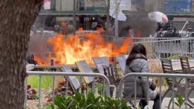
At least 77 people were killed when multiple wildfires swept across Greece’s Attica region. The death toll is expected to rise as rescue crews search for survivors.
READ MORE: 74 killed, 180+ injured by wildfires in Greece, authorities ask EU for help
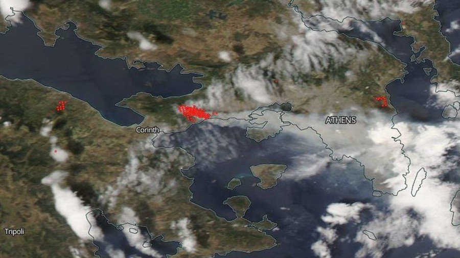
An image captured by NASA on July 24 shows the areas surrounding Athens which are still actively burning.
Two huge fires in Greece have flanked Athens, wreaking havoc in two separate areas outside the capital city. On July 24, our eye in the sky spotted the worst fires to hit Greece in at least a decade.🔴 = Actively burning areas Take a look: https://t.co/APi9G2AHl8pic.twitter.com/QQO1jQAhcg
— NASA (@NASA) July 24, 2018
Each hot spot, outlined in red, is an area where the thermal detectors recognized temperatures higher than background. The accompanying plumes of smoke, seen in the image, are indicative of fire, NASA said.
The EU’s Earth Observation Programme, known as Copernicus, also snapped some incredible images of the wildfires from space.
Images taken by the Sentinel satellite and shared by German imaging expert Pierre Markuse shows the extent of the Kineta wildfire. Dense smoke clouds can be seen billowing over the charred landscape.
Wildfire🔥 near Kineta #Greece🇬🇷 23 July 2018 Nat. col. + IR highlights #Copernicus#Sentinel-2A🛰️ Full-size: https://t.co/mTTIimWz4k#wildfire#Κινέταpic.twitter.com/8pl5mSmOVf
— Pierre Markuse (@Pierre_Markuse) July 23, 2018
This wildfire really has strong SWIR emissions, look how bright it appears in this SWIR image. It also produces quite dense smoke clouds. #wildfire#Κινέτα#Kinetapic.twitter.com/nm2YgqeFqg
— Pierre Markuse (@Pierre_Markuse) July 23, 2018
A nice view of the Kineta wildfire🔥 smoke plume reaching Athens here in this #Aqua🛰️ #MODIS image. Also visible in red the burn scar and still active fires. Clouds appear white in here, smoke light cyan. #wildfire#kinetapic.twitter.com/WluQDUh2j7
— Pierre Markuse (@Pierre_Markuse) July 23, 2018
Meanwhile, aerospace engineer Jorge Garcia examined the spread of nitrogen dioxide from the wildfires – a gas which is toxic if inhaled and which expedites the burning of combustible materials.
The NO2 plume from #Greece wildfires seen by @ESA_EO / @CopernicusEU new Sentinel-5p satellite through @tropomipic.twitter.com/5QgbTOfC79
— Jorge García (@JorgeGT) July 24, 2018
And a #Copernicus#Sentinel-5p🛰️ #Tropomi image showing the carbon monoxide emissions (CO total column) of the wildfire in #Kineta with parts of the smoke plume reaching Athens. @m_parrington@jmccarty_geopic.twitter.com/1s4r0HVFLV
— Pierre Markuse (@Pierre_Markuse) July 23, 2018
If you like this story, share it with a friend!