‘Our eyes in the sky’: India launches all-weather satellite to control borders
India successfully launched a new Earth observation satellite featuring radar imaging capable of penetrating through thick clouds. The new technology is believed to be used by the military for border control.
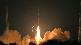
RISAT-2B, New Delhi’s brand new low-orbit satellite was launched on early Wednesday morning from the space center on the Sriharikota island in south-eastern India. Equipped with synthetic aperture X-band radar, the mission has “special imaging capabilities” as it allows all-weather surveillance, the Indian Space Research Organisation (ISRO) chief Kailasavadivoo Sivan told local media. Also, the satellite is carrying an Indian-made Vikram processor for the first time.
Also on rt.com India’s military research chief touts MORE ‘space deterrence’ weapons after satellite-killer testThe agency, however, did not disclose any images of the satellite, implying that it is likely to be used for military purposes. It is believed that its enhanced radar imaging features will enable the Indian army to keep track of activities on its borders. The brand-new optics are set to become “our eyes in the sky above,” India’s Defense Minister Chowkidar Nirmala Sitharaman tweeted.
Well done @isro. You make us proud, again and again. They shall be our eyes in the sky above - all weather. https://t.co/WGHe7xFchB
— Chowkidar Nirmala Sitharaman (@nsitharaman) May 22, 2019
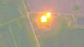
The satellite imaging issue raised public concerns in February as tensions escalated in the disputed region of Kashmir. Back then the Indian Army provided no images and videos of the cross-border air raid into Pakistani territory which according to New Delhi targeted a terrorist camp of the Jaish-e-Mohammed militant group. Some experts speculated that thick clouds prevented the existing Earth observation satellite technology, CartosSAT from capturing the operation.
If you like this story, share it with a friend!