Iconic LA landmarks built on top of fault lines, according to new earthquake map
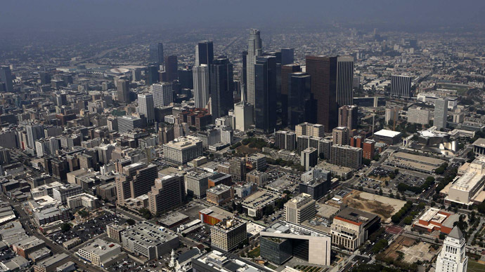
New maps released by the California Geological Survey are concerning residents in the southern part of the state who just now are being told that thousands of properties across Los Angeles and Hollywood are erected near newly discovered fault lines.
The CGS unveiled the preliminary copies of the maps — the first ones released by the agency in nearly two decades — earlier this year in January. According to a new analysis by journalists at the Los Angeles Times published this week, however, the earthquake experts believe a bit more of Southern California is susceptible to a major quake that once imagined.
Later this year the CGS will decide if it wants to officially approve the newest maps. If ongoing research indicates then that the recent drafts are accurate, though, then much of LA and Hollywood will turn out to have been built atop fault lines absent from earthquake reports until now.
“The mapped fault lines cut through more than 1,500 developed properties, according to a Times analysis of maps of the Hollywood fault and the Sierra Madre and Duarte faults in the northern San Gabriel Valley,” reporter Rong-Gong Lin II wrote on Tuesday this week for the newspaper.
According to the Times’ analysis, preschools, senior housing centers, luxury hotels and one of the largest housing developments in San Gabriel Valley have all been built either on or near the new lines. While maybe 1,500 developed properties are directly on the faults, the Times believes a total of 12,000 properties are within only 500-feet of being right on top of where subterranean tectonic plates meet.
If January’s maps are approved, then a long-standing California zoning law — the Alquist-Priolo Earthquake Fault Zoning, or AP, Act — will prohibit future construction along the faults unless builders pay for underground seismic testing.
“The intent of the AP Act is to ensure public safety by prohibiting the siting of most structures for human occupancy across traces of active faults that constitute a potential hazard to structures from surface faulting or fault creep,” the California Department of Conservation says on its official website.
But until now, the CGS has not had any new maps outlining exactly what parts of the state are affected by the AP act. If further testing allows the agency to adopt the newest maps, then the owners of thousands of properties that already exist in the region will have to determine what they want to do about it.
"There's a lot of unanswered questions," Jaime Edwards-Acton, the senior pastor at St. Stephen's, told the Times. "We have to figure out: Do we have to change anything?"
Others, like Group Delta consulting CEO Mike Reader, are already asking questions as a result of the Times report. Speaking to the Daily Mail this week, Reader said his group has carried out tests in the area contained in the CGS maps and found no evidence of fault lines.
“The big question is, is the map right - and that's still an open question,” he told the Daily Mail this week.
“There is a possibility that the map could be approved with the wrong information,” he added. “They need to withhold finalization of the map until more information is available.”
According to the Times, other properties that could be affected include the iconic Capitol Records tower in Hollywood, as well as landmark Sunset Strip hotels including the Mondrian, the Sunset Tower and the Standard.
The Standard “will take necessary precautions to ensure the
safety of their guests, which could potentially include
structural assessment or seismic investigation," spokeswoman
Kaitlin Kominsky told the LA Times.
Around two-thousand miles of California still needs to be mapped
out, the paper added, including regions of LA County's Westside,
Orange County, Pasadena, Lake Tahoe and the San Diego and San
Francisco Bay areas which may turn out to be susceptible to
earthquakes.